


- Ships and professional boats
- Service and Work boats
- Intervention ROV
- Shenzhen Qi Yuan Science
Intervention ROV W6 NAVIfor aquaculturefor underwater operationsinspection


Add to favorites
Compare this product
Characteristics
- Type
- inspection, underwater inspection, intervention, for underwater operations, for aquaculture
- Other characteristics
- deep water, for strong currents, rapid deployment, easy to deploy
- Maximum depth
350 m
(1148'03" )- Length
71 cm
(28 in)- Width
49 cm
(19 in)- Height
34 cm
(13 in)- Weight
23 kg
(51 lb)- Carrying capacity
10 kg
(22 lb)- Speed
3 kt
- Battery capacity
389 Wh
- Voltage
10 V, 26 V
Description
Product overview
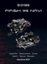
FIFISH W6 NAVI is a maritime remotely operated vehicle (ROV) engineered for search & rescue, offshore inspections and open-sea missions. It supports operations to 350 m depth, delivers strong propulsion and stable station-keeping in currents, and features a modular architecture with multiple port interfaces for rapid component and accessory swapping. The platform focuses on precise navigation, autonomous mission execution, high-resolution imaging, measurement and flexible tool integration for professional maritime tasks.
Key capabilities
Underwater Inertial Navigation (U-INS)
U-INS combines sensor fusion and deep-learning algorithms to deliver accurate position, velocity, heading and attitude data under water. Core functions include one-click return, POI (points-of-interest) marking, subsea mission planning and real-time motion tracking for autonomous waypoint execution and map integration.
Stability & control (Q-DVL and autonomy)
The integrated Q-DVL enables station-lock hovering and precise position locking to maintain stability against currents and environmental disturbances. Additional control features include downward collision avoidance and altitude tracking to support safe, repeatable inspections and intervention tasks.
Imaging & sensing
The dual 4K camera system provides an ultra-wide field of view for comprehensive situational awareness and inspection efficiency. Camera and imaging specifications include:
Measurement & mapping
W6 NAVI integrates QYSEA measurement and bathymetric tools. The built-in laser scaler combined with QY-MT software enables precise online and offline measurements (length, width, area, perimeter, angles) with millimeter-level accuracy. The QY-BT bathymetric tool supports intelligent 2D and 3D seafloor mapping, delivering contour and depth data for survey workflows.
Optional sensors & integrations
The platform supports multi-tool integrations to extend capability. Available or integrable tools include 2D imaging sonar for low-visibility conditions, station lock modules (DVL), underwater positioning modules (U-QPS), robotic manipulators and retrieval tools, water and sediment samplers, multi-parameter sensors and other modular accessories to suit inspection, retrieval, measurement and survey tasks.
Power system
Removable 388.8 Wh swappable battery supports extended operations and quick turnaround via fast charging (70% in ~1 hour). An optional direct power supply can be specified for continuous-deployment scenarios.
Applications
Typical use cases include search & rescue, large vessel hull and sea-chest inspections, bridge and subsea structure inspection, mooring line checks, offshore infrastructure surveys, aquaculture monitoring, marine research and exploration, film & media capture, and industrial maritime surveys.
Overview (table items)
Underwater Inertial Navigation: included (U-INS) / Station Lock Hovering: supported (Q-DVL) / Downward Collision Avoidance: supported / Underwater Positioning: supported (optional modules available)
Technical specifications
FIFISH W6 NAVI is a maritime remotely operated vehicle (ROV) engineered for search & rescue, offshore inspections and open-sea missions. It supports operations to 350 m depth, delivers strong propulsion and stable station-keeping in currents, and features a modular architecture with multiple port interfaces for rapid component and accessory swapping. The platform focuses on precise navigation, autonomous mission execution, high-resolution imaging, measurement and flexible tool integration for professional maritime tasks.
Key capabilities
- Diving depth: 350 m
- Dual 4K UHD camera system (ultra-wide FOV)
- LED lighting: 12,000 Lumen
- Payload capacity: 10 kg
- Omnidirectional movement: 360°
- Underwater Inertial Navigation System (U-INS) for position, velocity, heading and attitude
- Modular design with multiple port interfaces for quick component and accessory swapping
- Removable 388.8 Wh battery with fast charge capability (70% in ~1 hour)
Underwater Inertial Navigation (U-INS)
U-INS combines sensor fusion and deep-learning algorithms to deliver accurate position, velocity, heading and attitude data under water. Core functions include one-click return, POI (points-of-interest) marking, subsea mission planning and real-time motion tracking for autonomous waypoint execution and map integration.
Stability & control (Q-DVL and autonomy)
The integrated Q-DVL enables station-lock hovering and precise position locking to maintain stability against currents and environmental disturbances. Additional control features include downward collision avoidance and altitude tracking to support safe, repeatable inspections and intervention tasks.
Imaging & sensing
The dual 4K camera system provides an ultra-wide field of view for comprehensive situational awareness and inspection efficiency. Camera and imaging specifications include:
- Pixels: 12 Megapixels
- Lights: 12,000 Lumen LEDs
- Lens: Ultra-wide FOV lens
- Horizontal FOV: 166°
- Vertical FOV: 100°
- ISO: up to 6400 (max)
Measurement & mapping
W6 NAVI integrates QYSEA measurement and bathymetric tools. The built-in laser scaler combined with QY-MT software enables precise online and offline measurements (length, width, area, perimeter, angles) with millimeter-level accuracy. The QY-BT bathymetric tool supports intelligent 2D and 3D seafloor mapping, delivering contour and depth data for survey workflows.
Optional sensors & integrations
The platform supports multi-tool integrations to extend capability. Available or integrable tools include 2D imaging sonar for low-visibility conditions, station lock modules (DVL), underwater positioning modules (U-QPS), robotic manipulators and retrieval tools, water and sediment samplers, multi-parameter sensors and other modular accessories to suit inspection, retrieval, measurement and survey tasks.
Power system
Removable 388.8 Wh swappable battery supports extended operations and quick turnaround via fast charging (70% in ~1 hour). An optional direct power supply can be specified for continuous-deployment scenarios.
Applications
Typical use cases include search & rescue, large vessel hull and sea-chest inspections, bridge and subsea structure inspection, mooring line checks, offshore infrastructure surveys, aquaculture monitoring, marine research and exploration, film & media capture, and industrial maritime surveys.
Overview (table items)
Underwater Inertial Navigation: included (U-INS) / Station Lock Hovering: supported (Q-DVL) / Downward Collision Avoidance: supported / Underwater Positioning: supported (optional modules available)
Technical specifications
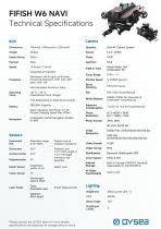
- Model: W6 NAVI
- Maximum operating depth: 350 m
- Cameras: Dual 4K UHD (12 MP per camera)
- Horizontal FOV: 166°
- Vertical FOV: 100°
- Maximum ISO: 6400
- LED lighting output: 12,000 Lumen
- Payload capacity: 10 kg
- Movement: 360° omnidirectional
- Navigation: U-INS (position, velocity, heading, attitude); one-click return; POI marking; subsea mission planning; real-time motion tracking
- Stability: Q-DVL station lock hovering; downward collision avoidance; altitude tracking
- Measurement: Built-in laser scaler + QY-MT software; millimeter-level measurement of length, area, perimeter, angles
- Mapping: QY-BT bathymetric tool for 2D & 3D seafloor mapping
- Power: Removable 388.8 Wh swappable battery; fast charge to 70% in ~1 hour; optional direct power supply
- Modularity: Multiple port interfaces for quick accessory/component replacement and multi-tool integrations (2D sonar, manipulators, samplers, sensors, etc.)
VIDEO
Catalogs
Other Shenzhen Qi Yuan Science products
FIFISH ROV


Related Searches
- Underwater ROV
- Intervention underwater ROV
- Observation underwater ROV
- Aquaculture underwater ROV
- Underwater drone
- Underwater photography drone
- Portable ROV
- Electric underwater drone
- Easy to deploy ROV
- Light ROV
- Scientific research underwater drone
- Aluminum underwater drone
- Deep water ROV
- Oceanographic survey underwater drone
- Preventive maintenance ROV
- Aquaculture underwater drone
*Prices are pre-tax. They exclude delivery charges and customs duties and do not include additional charges for installation or activation options. Prices are indicative only and may vary by country, with changes to the cost of raw materials and exchange rates.