
- Maritime equipment
- Navigation, Communications, Electronics
- Oceanographic survey sonar
- Imagenex Technology Corp.
Oceanographic survey sonar YellowFinside scanhigh-resolution

Add to favorites
Compare this product
Characteristics
- Application domain
- for oceanographic surveys
- Technology
- side scan
- Other characteristics
- high-resolution
- Max. depth
300 m
(984'03" )- Operating frequency
260 kHz, 330 kHz, 800 kHz
- Supply voltage
Max.: 55 V
Min.: 40 V
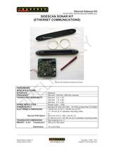
Description
The Imagenex Model 872 “YellowFin” is a full-featured dual channel, high resolution, sidescan sonar. The YellowFin is an affordable, very user friendly system that incorporates a high speed Ethernet connection to your Windows™ based laptop or desktop PC. Integrated power and a built-in differential-ready GPS receiver complete this fantastic system. Zoom windows are available for target investigation without interrupting real-time data acquisition. Data is displayed in real-time, with or without speed correction, in 9 user selectable colour tables.
Features
Triple frequency
High resolution 1000 data points per side
300 m depth rating
Up to 400 m (1300') total coverage
23 m (75') tow cable included
LAN compatible
Built-in track plotter
Built-in internal GPS receiver
Record to .XTF in real-time
Applications
Underwater Archaeology
Sunken Timber Recovery
Search & Recovery
Surveying
Law Enforcement Work
Scientific Research
Environmental Survey
Catalogs

872_YellowFin_Specs_rev3
2 Pages
Other Imagenex Technology Corp. products
Sidescan


*Prices are pre-tax. They exclude delivery charges and customs duties and do not include additional charges for installation or activation options. Prices are indicative only and may vary by country, with changes to the cost of raw materials and exchange rates.