
- Products
- Catalogs
- News & Trends
- Exhibitions
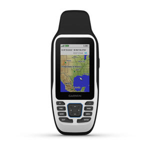
GPS multi-purpose instrument GPSMAP® 86imarinecolorportable

Add to favorites
Compare this product
fo_shop_gate_exact_title
Characteristics
- Function
- GPS
- Application domain
- marine
- Technology
- color
- Mount
- portable
- Other characteristics
- waterproof
Description
CAST OFF CONFIDENTLY WITH A PREMIUM MARINE HANDHELD GPS
Stay on course with the GPSMAP 86i handheld. It provides all the outdoor functions and global communications of the GPSMAP® 66 series and adds on-the-water features — including wireless connectivity to your onboard marine system.
It’s water-resistant, and it floats, so it’s as at home on the water as you.
See all your marine system info at a glance with boat data streaming.
Cruise with peace of mind. inReach interactive SOS is there if you need it2.
Send and receive text messages from anywhere2.
Put convenient control of your autopilot and Fusion® systems at your fingertips.
Stay out longer with up to 35 hours of battery life in 10-minute tracking mode.
BOAT DATA
Sync with compatible Garmin chartplotters and instruments to see real-time boat data displayed right on your handheld.
FUSION-LINK AUDIO
Get convenient remote operation of select onboard Fusion marine products.
ACCURATE TRACKING
When you’re underway, an adjustable GPS filter smooths speed and heading indications as you pass over swells for more accurate tracking.
WORLDWIDE BASEMAP
See worldwide shaded relief coverage, including oceans, seas, major lakes and rivers. And see international and state political boundaries and time zone information.
BLUECHART COVERAGE
Add optional BlueChart g3 coastal charts give you leading-edge coverage, clarity and detail with integrated Garmin and Navionics data.
VIDEO
Exhibitions
Meet this supplier at the following exhibition(s):


Related Searches
- Garmin boat antenna
- Garmin boat sensor
- Garmin temperature sensor
- Radome antenna
- Garmin sonar
- Video surveillance video camera
- Radio
- Garmin multi-purpose instrument
- Marine radio
- Garmin depth transducer
- Garmin fixed multi-purpose instrument
- VHF radio
- Garmin boat multi-purpose instrument
- Display
- Garmin chart plotter multi-purpose instrument
- Garmin satellite multi-purpose instrument
- Fixed video camera
- Boat remote control
- Boat display
- Garmin GPS multi-purpose instrument
*Prices are pre-tax. They exclude delivery charges and customs duties and do not include additional charges for installation or activation options. Prices are indicative only and may vary by country, with changes to the cost of raw materials and exchange rates.

