
{{product.productLabel}} {{product.model}}
{{#if product.featureValues}}{{product.productPrice.formattedPrice}} {{#if product.productPrice.priceType === "PRICE_RANGE" }} - {{product.productPrice.formattedPriceMax}} {{/if}}
{{#each product.specData:i}}
{{name}}: {{value}}
{{#i!=(product.specData.length-1)}}
{{/end}}
{{/each}}
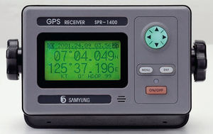
{{{product.idpText}}}
{{product.productLabel}} {{product.model}}
{{#if product.featureValues}}{{product.productPrice.formattedPrice}} {{#if product.productPrice.priceType === "PRICE_RANGE" }} - {{product.productPrice.formattedPriceMax}} {{/if}}
{{#each product.specData:i}}
{{name}}: {{value}}
{{#i!=(product.specData.length-1)}}
{{/end}}
{{/each}}
{{{product.idpText}}}
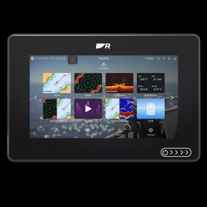
... Axiom 2 chartplotters deliver faster performance and upgraded processing power in 7-, 9-, or 12‑inch sizes. Available as chartplotter‑only or with built‑in RealVision™ sonar. The Marine Chartplotter You Trust. Now Even Better Our most popular marine ...
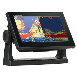
... GPS/WAAS CHART PLOTTER with built-in CHIRP FISH FINDER 9" GPS Chart Plotter/Fish Finder with Tablet Control/Mirroring function Available. Wireless Connection to Smartphone and tablet NEW View your GP-1871F/1971F screen on your tablet or smartphone. At ...
Furuno
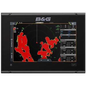
... The B&G Vulcan 7 is a great value, sailing chartplotter designed for coastal cruising and club racing. This easy-to-use, intuitive 7-inch multi-touch screen is packed with B&G’s unique sailing features including SailSteer and RacePanel. Simply integrate ...
... Overview
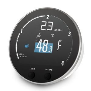
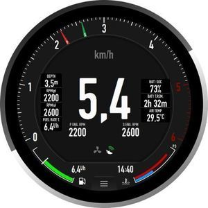
The VMH 35-D GPS is a compact multifunction display built as a standalone instrument for monitoring diesel engines and vessel parameters. It integrates a high-performance GPS receiver for speed, position and heading and supports 12V ...
... Enjoy the Plug and Play installation thanks to the dedicated harness equipped with mating Suzuki* connectors. A sleek, high-tech digital display for performance monitoring of your Suzuki*-powered boat. The Digital sun-readable display with analog inputs, ...
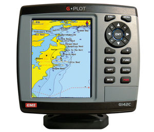
... The GME G-Plot offers a simple to use highly featured GPS chartplotter. Incorporating a 16 channel internal GPS antenna for fast GPS updates, perspective view, animated navigation markers and plotter mode are some of the many functions of this unit. Multiple ...
GME electrophones

... Brite 4.3- inch Color LCD Display 4.3- inch Color LCD Display provides larger letters and a variety of colors for high visibility even under bright sunlight. More accurate position 72 channel parallel gives more accurate position on “Position”, ...
10" Color Sunlight Viewable WAAS GPS / C-Map MAX compatible Chart Plotter
Standard horizon
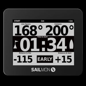
... TRY TO FIND A MORE ADVANCED SAILING INSTRUMENT. WE’LL WAIT. START BETTER Ping the boat, ping the pin and our navy grade GPS will guide you to the line with 0.3m accuracy. There is no excuse to ever be early or late again. SAIL FASTER In every ...
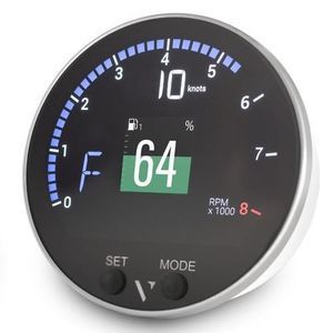
... Product Overview
The E360 is a premium 4-inch round touchscreen marine gauge and chartplotter designed to upgrade your boat’s cockpit with a blend of luxury and retro elegance. Featuring an intuitive interface, advanced features, and a unique ...
LXNAV d.o.o.
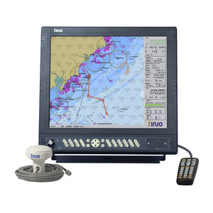
... · Passed China Classification Society CCS type approval. · Support Ethernet, WIFI and 4G network communication. · Support to update software online. HM-5817 electronic chart system meets the standard of Class A ECS. It uses high-performance processor ...
Xinuo Information Technology (Xiamen) Co.,Ltd
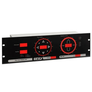
The OMC-131 True wind display is specially designed for easy read out of "true" and "relative" wind information on board sea going vessels. The unit is suitable for panel mounting as well as mounting into a standard 19" rack. Any inclination is allowed ...
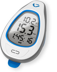
... GPS for SUP The Makai is the first GPS that’s specifically designed for SUP. It measures the Doppler shift in GPS signals to calculate your speed every half-second. Optimize your stroke without interrupting it The Makai's big numbers let you see ...
... Features • Compliant with IMO and MSC standard. • Small size, Light weight, Easy installation. • All data with big letters can be displayed in one screen. • Interface with PC to print out destination, mark and routes. • No need ...
Navis USA LLC