
{{product.productLabel}} {{product.model}}
{{#if product.featureValues}}{{product.productPrice.formattedPrice}} {{#if product.productPrice.priceType === "PRICE_RANGE" }} - {{product.productPrice.formattedPriceMax}} {{/if}}
{{#each product.specData:i}}
{{name}}: {{value}}
{{#i!=(product.specData.length-1)}}
{{/end}}
{{/each}}
{{{product.idpText}}}
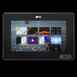
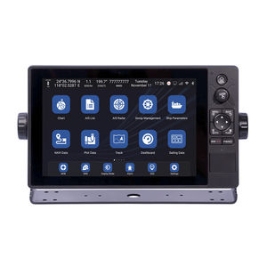
... Axiom 2 chartplotters deliver faster performance and upgraded processing power in 7-, 9-, or 12‑inch sizes. Available as chartplotter‑only or with built‑in RealVision™ sonar. The Marine Chartplotter You Trust. Now Even Better Our most popular marine ...
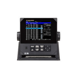
... Refined UI for greater visibility and operability, NAVTEX Receiver contributing to safe navigation. The Furuno NX-900 NAVTEX receiver automatically receives, displays, prints (via an optional printer) and sends data to navigation equipment such as ECDIS, ...
Furuno
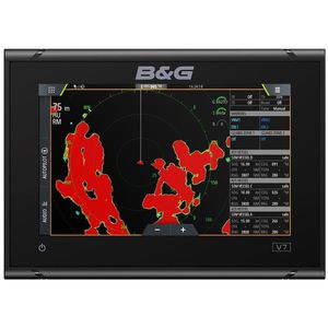
... The B&G Vulcan 7 is a great value, sailing chartplotter designed for coastal cruising and club racing. This easy-to-use, intuitive 7-inch multi-touch screen is packed with B&G’s unique sailing features including SailSteer and RacePanel. Simply integrate ...
B & G
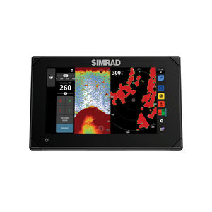
Take your experience to a whole new level with the Simrad® NSX smart chartplotter and fishfinder. With an innovative, modern interface featuring powerful navigation capability with C-MAP® DISCOVER X charts, you’ll see everything like never before, our ...
Simrad Yachting
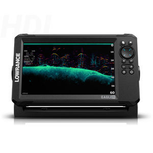
... With razor sharp vision, the Eagle was born to fish. Get autotuning sonar, detailed C-MAP charts, and an always-visible IPS screen. That’s everything you need to dominate out on the water with total ease and no distractions. Enhanced transducer options The ...
Lowrance

... Product description
Compact vessel instrument to display multiple navigation and engine parameters in a small footprint.
Key information
- Series: VMH
- Function: Rudder, Trim, Speed, Engine revolution,
VERATRON
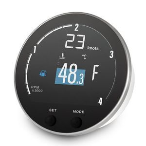
... Overview
The VMH 35-D GPS is a compact multifunction display built as a standalone instrument for monitoring diesel engines and vessel parameters. It integrates a high-performance GPS receiver for speed, position and heading and supports 12V ...
VERATRON
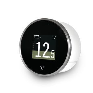
... Overview
Compact marine multifunction display for monitoring engine and boat data with SAE J1939 connectivity.
Product description
The VMH Flex presents extensive boat and engine information in a compact 60 mm housing. The innovative ...
VERATRON
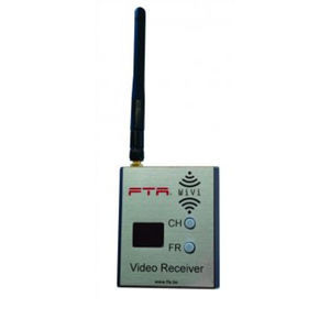
... Product
- Video receiver WVRX
Overview
- Frequency: 5.8 GHz
- Channels: 48
- Antenna: 2 dBi omnidirectional
- Antenna connector: SMA (compatible with other antennas)
- A/V outputs:
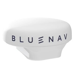
... Guided by accuracy The GPS Precision+ by BlueNav is a high-precision marine GNSS receiver based on Galileo HAS technology. It provides accuracy up to 20 cm. Designed to enhance our Smart Navigation solutions, it becomes the key to smart mooring and uncompromised ...

Shipcontroller DPS is an automatic control system that maintains the boat’s position and heading within very tight margins of error. Launched in 2021, it marked a milestone by being the first affordable, general-purpose DPS system that can be installed ...
... Our digital LCD barographs have an USB port for connection to a PC or onboard data system. A CD-ROM with software for evaluation and display of the data on a PC is included as standard. Storage of the data for up to 56 days User-selectable display ...
Barigo
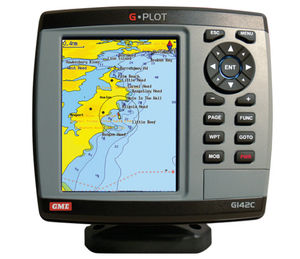
... The GME G-Plot offers a simple to use highly featured GPS chartplotter. Incorporating a 16 channel internal GPS antenna for fast GPS updates, perspective view, animated navigation markers and plotter mode are some of the many functions of this unit. Multiple ...
GME electrophones

... Professional plotter with impressive operability fully supports to improve your fishing efficiency Save important data in your SD card The display unit has “memory” inside, and data of mark, own track, draw, target track, route, picture and setting ...
Koden electronics

... Associated with the pilot, multifunction and crew transmitters, it guarantees your safety and that of your crew. The Radio Receiver must be installed in a safe place on board and connected to the Topline Bus. It can manage up to 8 transmitters simultaneously ...
nke Marine Electronics
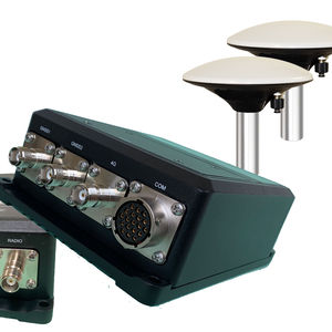
... 1 cm Position, 0.01° Heading Capable Professional RTK receiver suitable for USVs, dynamic positioning, hydrographic and scientific applications Dual marine grade antenna for precise heading calculations FCC and CE certified Built-in web user interface ...
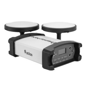
The Vector™ VS1000 is Hemisphere GNSS’ premiere multi-GNSS, multi-frequency receiver designed specifically for the professional marine market. Providing precise heading, Athena RTK positioning, and full Atlas Global Correction Service capability, its ...
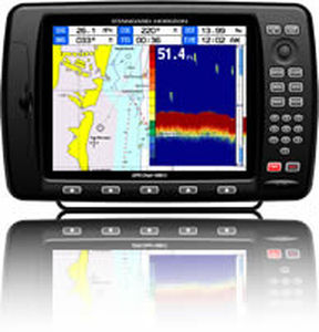
10" Color Sunlight Viewable WAAS GPS / C-Map MAX compatible Chart Plotter
Standard horizon

... This rugged directional receiver provides range and bearing to the ATT-400 series of transponders or acoustic pingers operating from 8kHz to 45kHz. Designed for small boat operations, the STI-350 uses a directional hydrophone and adjustable staff assembly ...
RJE International Inc.
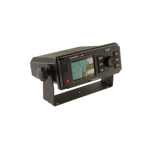
... The SMARTFIND M5 AIS Class A transponder is packed with powerful features. It is the first to include an AIS MOB and AIS SART alarm function, with a Steer To Rescue MOB display enabling you to quickly and easily navigate to the location of the MOB. ...
McMurdo
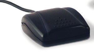
... The Nobeltec USB GPS 9P Portable is an easy-to-use, affordable and feature filled GPS solution. The GPS module receiver will track up to 20 satellites at a time while providing navigation updates once every second (1Hz). USB interface for plug-and-play ...
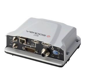
The LD8 is a high-precision GNSS receiver that provides reliable and accurate positioning. The compact and lightweight receiver offers industry-leading GNSS multi-constellation heading and positioning data for dynamic environments. L-Band signals can ...
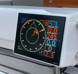
... 100% customizable, 10-inch state of the art graphics display, offering crisp and crystal-clear readability in all conditions. FLEXIBILITY Configure your display with free format values, digits, graphs, and data layouts with our NavDesk app. Allowing ...
Sailmon GmbH
... The Veethree GPS Receiver is the most accurate solution for converting an existing electrical speedometer into a GPS speedometer. Standard GPS with 1-second (1Hz) update rate that outputs NMEA 0183 info. Fast update GPS with 1/10-second (10Hz) update ...
... Product Overview
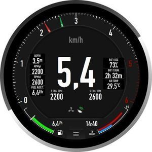
The E360 is a premium 4-inch round touchscreen marine gauge and chartplotter designed to upgrade your boat’s cockpit with a blend of luxury and retro elegance. Featuring an intuitive interface, advanced features, and a unique ...
LXNAV d.o.o.
... · Passed CE certification, CCS type approval. · Support Ethernet, WIFI and 4G network communication. · Support C-MAP (MAX) and S-63 chart format. XN60 series multi-function intelligent display integrates functional modules such as GNSS, chart plotter, ...
Xinuo Information Technology (Xiamen) Co.,Ltd
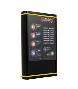
... Description An 'à la carte' configuration for cruising or racing multihulls. The UpSideUp Master's version offers an access to all the available functions of the UpSideUp solutions and the possibility of specific features developed on request. This ...
OCEAN DATA SYSTEM