
{{product.productLabel}} {{product.model}}
{{#if product.featureValues}}{{product.productPrice.formattedPrice}} {{#if product.productPrice.priceType === "PRICE_RANGE" }} - {{product.productPrice.formattedPriceMax}} {{/if}}
{{#each product.specData:i}}
{{name}}: {{value}}
{{#i!=(product.specData.length-1)}}
{{/end}}
{{/each}}
{{{product.idpText}}}

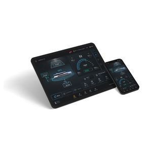
... Out now! Your Multifunction Displays Companion ALWAYS CONNECTED Raymarine App is your digital companion for Raymarine marine electronics and connected boating. Transform your mobile device into a remote Axiom display. Connect and monitor your boat ...
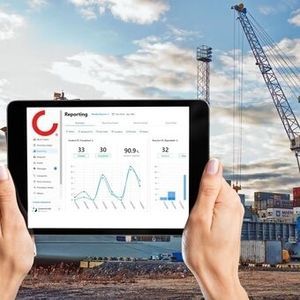
... Konecranes Port Services is a range of after-sales services for port equipment which includes: Asset protection port services such as maintenance, spare parts and inspections Asset improvement port services such as retrofit technology, equipment modernization ...
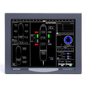
Alphatron AlphaConning software is a user-friendly software package supported by Alphatron Marine. The I/O hardware interfaces developed by Alphatron make it possible to connect additional instruments and display them on the AlphaScreen instead of separate ...
Alphatron Marine

... A direct connection with your FPT engine. Engine information and support through your smartphone. THE PERFECT APP FOR YOUR ENGINE MyFPT is an app with a quick and easy setup: just type your engine serial number and all your main engine information ...

... Global leaders in marina services equipment, Rolec have launched their new cloud-based marina services management system, BerthVend, providing a streamlined service provision for both marina operators and berth holders. The marina landscape is changing; ...

... Overview
Our portfolio includes two software programs for remote reading of power and water meters and remote control of utility delivery: TALLYBEE and TALLYWEB. Both provide an intuitive online administration module to manage services with ...
... Overview:
- SM-Panoptis by Smartmarinas is a web-based platform for real-time monitoring, logging and analysis of water and electricity supply pillars in ports and marinas.
Pillar Data Logging:
- Serial

... CloudEnergy's access control is the first Smart system for remote, app-based and cloud-based management of harbours, campsites and rest areas. With CloudEnergy you can: Automatically subscribe to the system via credentials or Qrcode Manage charges securely ...
... CloudEnergy - The Smart Solution for Access Management CloudEnergy revolutionises access control in your facilities by offering a hybrid system based on RFID wristbands and QR codes. Our cloud platform enables guests to easily, quickly and securely ...
... Robust & Reliable Marine grade hardware Intuitive UI: Available as an app on iOS, Android, and major marine MFD (Multi-Function Display) systems Cloud Connectivity: Dashboard & Analytics IoT Boat Control Module & UI The Helios Marine Link is a smart ...
... ⚠ Note: Only available with BlueNav electric motors. BlueNav Smart Navigation Software Safer, Smarter, and Easier Boating. Nearly 20% of boating incidents occur during low-speed manoeuvres, often in harbours where wind, current, and limited space make ...
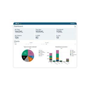
... Web app to monitor waste collection performance and CSR reporting for marinas. Compatible with DPOL® and other collection systems. DPOL® Impakt is a web application, available on all operating systems, designed to record and monitor waste collected ...

... The new IPE IMES Performace Evaluation Software designed for 2- and 4-stroke diesel engines loads cylinder pressure data from EPM-XP directly and gives a quick and very reliable view on many operational aspects. Furthermore it recommends actions to ...

Purpose: The Global Maritime Distress and Safety System (GMDSS) simulator reproduces a realistic shipboard and shore environment for training GMDSS operators and radio specialists. Designed for simulator-based training, competence assessment and ...
STORM SIM
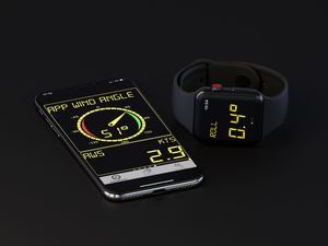
... The nke Display Pro app is the ideal application to complete your electronic installation. It is available on iOS (iPhone, iPad and Apple Watch) and on all Android devices. Download nke Display Pro app on the Apple Store Download nke Display Pro app ...
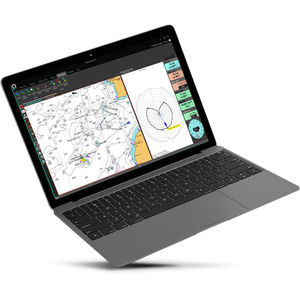
TZ Navigator software has been designed to answer the navigation needs and requirements of recreational sailors. With features that are truly cutting-edge, it is a software that takes you from cruising with your powerboat or yacht, to racing in regattas. ...
MaxSea International
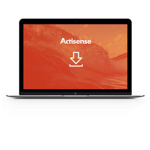
... NMEA Reader Software The Actisense team have developed powerful software tools to enable customers to view and diagnose any potential network problems quickly and easily. NMEA Reader can be used with the NGT-1 NMEA 2000 PC Interface to view information ...
Actisense
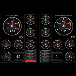
Whether you are interested in monitoring your vessel’s systems while underway or remotely from your home or office, Maretron’s N2KView® software displays the information you need including engines, generators, tanks, rudders, navigation instruments, local ...
Maretron

Small, rugged, and easy to use, the SPOT Gen4 provides a simple turn-key communication option for remote and lone workers. Inexpensive and reliable, the Gen4 allows users the ability to report locations using pre-set messaging for check-in and have access ...
Globalstar Europe Satellite Services Ltd.
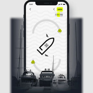
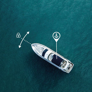
... The SMARTDOCK app is transforming on-board maneuvering: instead of being tied to a fixed joystick or helm station, you can control your boat directly from your smartphone, wherever you are on deck. Thanks to the intelligent ...
... ENJOY YOUR CRUISE WITH OCTOPUS Avoiding high winds and waves, visualizing your sailing and motoring periods, anticipating weather conditions on the mooring area… Cruising enthusiasts, you have specific needs and Octopus software is there to fit them! Adrena ...
Adrena
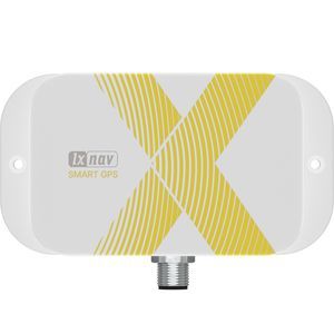
... Product Overview
SmartGPS is a vessel tracking device equipped with an integrated NMEA2000 GPS antenna, designed for real-time monitoring and management of marine vessels. It offers advanced tracking, monitoring, and analysis features, making ...
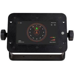
The sMRT SARfinder is a digital monitoring and alerting unit designed for maritime safety. It continuously monitors the emergency frequency 121.5 MHz and provides an instant audible alarm and direction bearing when a distress signal is received from compatible ...
MRT

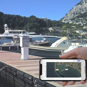
... i-Marina helps harbormasters to automate the key aspects of managing harbor operations efficiently, fast and very professional. i-Marina allows them to operate their harbor using a laptop, tablet or mobile phone. An interactive plan of the harbor ...
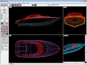
The Autoship hull design/surface modelling program combines the graphical user interface of Windows with the dexterity of NURBS (Non-Uniform Rational B-Spline) mathematics, the high-end CAD standard for surface modelling, to give you the tools to quickly ...
Autoship, Coastdesign Norway AS
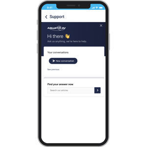
... Managing and registering your Aquatic AV devices is easy with the Aquatic AV App. Create a free Aquatic AV account to register and manage all your purchases Organize your devices by installation environment for quick access Register your Aquatic AV ...