
{{product.productLabel}} {{product.model}}
{{#if product.featureValues}}{{product.productPrice.formattedPrice}} {{#if product.productPrice.priceType === "PRICE_RANGE" }} - {{product.productPrice.formattedPriceMax}} {{/if}}
{{#each product.specData:i}}
{{name}}: {{value}}
{{#i!=(product.specData.length-1)}}
{{/end}}
{{/each}}
{{{product.idpText}}}

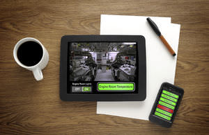
Out now! Your Multifunction Displays Companion ALWAYS CONNECTED Raymarine App is your digital companion for Raymarine marine electronics and connected boating. Transform your mobile device into a remote Axiom display. Connect and ...
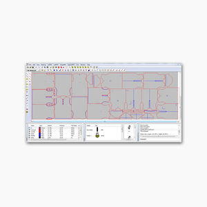
Eastman’s operating control software is a dynamic, all-inclusive platform that makes it effortless to operate Eastman’s automated cutting system. Included with your system investment, cutPRO makes it easy to import files ...
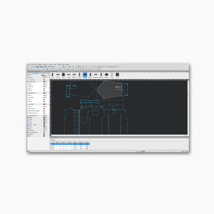
Eastman’s patternPRO design and nesting software is a comprehensive set of tools to help you design pattern pieces from the start with the program’s drafting and editing tools, or even edit and finalize your existing ...
Once Imported the items to be cut can be sorted by material, color and thickness, this allows the user to select, for example, all 2mm Blue Vinyl material from multiple orders to run them in a single run, thus, saving time on organizing ...
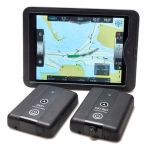
The SafePilot Piloting Software is a professional piloting/navigation iOS based software that is developed in collaboration with marine pilots worldwide. Known for its intuitive ease of use, the SafePilot ...
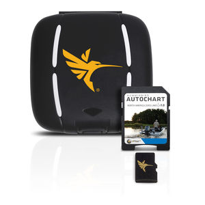
The Zero Lines map card is the starting point for building your own maps with AutoChart or AutoChart Live. With these all-important Zero Lines as your foundation, you can begin creating your own, accurate and detailed maps of any fishing ...
Humminbird

... cargo and ballast monitoring software that acts as the eyes and ears of seafarers, allowing constant monitoring of all the critical parameters of liquid cargo tanks. What Is It? CargoBoss is a user-friendly software ...
... intuitive visualisation software Intuitive visualisation software with comprehensive standard function templates Can be used flexibly thanks to web-based interface Easy to adapt to customer ...

The Sonar 5 post-processing software is specifically designed to identify and count fish tracks. Sonar 5 can automatically track fish and can for example provide information on numbers of fish, swimming speed and direction ...
Simrad

Featuring a state-of-the-art dive log, planner and device configuration, Reef provides a complete dive tool for every diver no matter experience, level or dive style. It is designed to maximize your passion of diving by extending the ...
The AHD-Com software allows simultaneous communication with several participants in different locations by multiple video conferences based on “Videoconferencing over IP”. Product Features Worldwide multiple video ...
... are interested in monitoring your vessel’s systems while underway or remotely from your home or office, Maretron’s N2KView® software displays the information you need including engines, generators, tanks, rudders, navigation ...
Maretron

Maretron’s N2KView® Mobile software allows you to monitor and control your vessel’s systems from your smart phone or tablet device. This includes Android (2.2 and higher) smart phones and tablets as well as Apple iPod, ...
Maretron
Maretron Real Time Cloud Service allows you to remotely and seamlessly connect to your vessel using N2KView® or N2KView®-Mobile software, so you can monitor and control your vessel from anywhere in the world. As long ...
Maretron
Integrated Positioning Software (IPS) works with LXT, Trackpoint II, Trackpoint 3, Trackpoint 3P, BATS, and BATS Portable. Combines GPS position with Trackpoint date to calculate the position of submerged target.

GDS Simulator is intended for practical training in using portable gas detectors for testing atmosphere in ship enclosed spaces. Configuration Simulator consists of Instructor WorkPlace (IWP), and Student WorkPlaces (SWP). IWP ...
STORM SIM
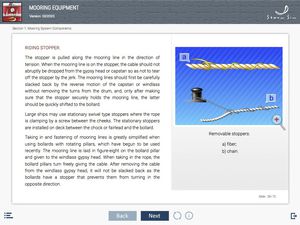
E-learning modules (ELM) library is designed for theoretical training of Ratings as Able Seafarer Deck and ratings forming part of a navigational watch (RFPNW). Content: - Signs of ship classification - Steering gear - Anchor ...
STORM SIM
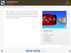
E-learning modules (ELM) library Shiphandling basics is designed for theoretical training of navigators in accordance with Chapter II of the STCW Convention in the part concerning shiphandling. Content: - Ship maneuverability - ...
STORM SIM
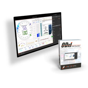
ODxI is an ODS Solution offering powerful, multipurpose and intuitive software allowing the development of qualitative and efficient user interfaces (HMI). Designed specifically to meet the needs of ...

Qinertia PPK software offers an all-new level in high-precision positioning solutions. In a world that demands accuracy without compromise, our software is emerging as the cornerstone for professionals ...
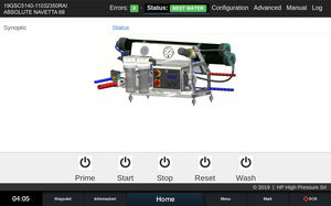
HP Part-Net - The first user interface for watermakers for navigation plotters. We are proud to introduce the first user interface compatible with Garmin, Raymarine and Furuno plotters in the world. HP ...

The SmartPlus Cloud software allows to view the data from the E-Power sockets in a web environment that can be queried online via any mobile or desktop device equipped with a web browser. The cloud platform can be accessed ...
... rapidly becoming scarce and expensive if not obsolete. A system failure can be very costly. Apart from having a modern user interface and advanced system capabilities our system is based on standard PC components giving ...
Kockum Sonics

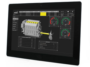
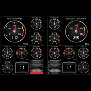
The new IPE IMES Performace Evaluation Software designed for 2- and 4-stroke diesel engines loads cylinder pressure data from EPM-XP directly and gives a quick and very reliable view on many operational aspects. Furthermore ...
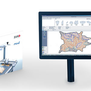
Modular software components for your specific requirements MindCUT Studio Production V5 The Mind software is modular. The MindCut Studio Production basic package contains all the essential functions ...
Zünd Systemtechnik AG

Digital Cutting Software With Zünd Cut Center - ZCC, you are always a step ahead! Software designed to take you further Zünd Cut Center software facilitates every aspect of the ...
Zünd Systemtechnik AG

... adjusted according to the specified material thickness. 3D Visualization Adobe® Illustrator® lets you work in a professional software environment with a myriad of functions and design options. In 3D ZDC preview, you ...
Zünd Systemtechnik AG

Physical access control management. Autonomy, simplicity and security of your pedestal The fluid management system is totally autonomous and can be fitted to almost all the existing Sourcelec and Sourcinox pedestals. It provides different ...
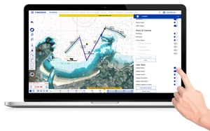
... regattas. TIMEZERO software has two main objectives: Supreme control and comfort. Discover in this section how TIMEZERO software caters to your needs no matter your marine navigation type. The cutting ...
MaxSea International
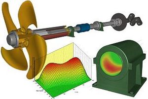
... train calculations. The ShaftDesigner software uses a base model to calculate shaft alignment, whirling vibration, bending (lateral) vibration, axial vibration and torsional vibration. The ShaftDesigner software's ...
NMEA Reader Software The Actisense team have developed powerful software tools to enable customers to view and diagnose any potential network problems quickly and easily. NMEA Reader can be used with ...
Actisense
... , tiered approach enables you to assign the right level of functionality based on the user or site’s unique requirements. Software tiers can be upgraded with additional functionality as needed, and evolve with the site ...
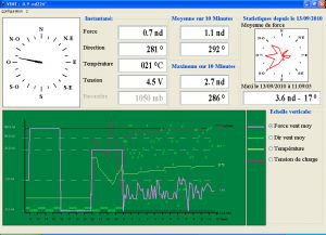
Software for recording and graphic representation of wind data and atmospheric pressure for LCJ Capteurs wind vane-wind speed indicators. For Windows.
Please specify:
Help us improve:
remaining